
THIS ANNOUNCEMENT CONTAINS INSIDE INFORMATION AS STIPULATED UNDER THE
("
Mineral Resource Upgrade
As previously reported, the 2016 MRE in the IMA covered 47 hectares, however, the aircore drilling assay results received to date indicate the mineralisation extends substantially to the west and at depth and now extends across an area around 3.2 times larger at 152 hectares (using a bottom cut of 2% Heavy Minerals (HM)).
Highlights
· Maintaining a 5% HM bottom cut delivers 4.8 times increase in resource tonnes in the IMA, from 897kt to 4.3Mt at an average resource grade of 10.5% HM.
· Applying a 2% HM bottom cut delivers 14.6 times increase in resource tonnes from 897kt to 13.1Mt at an average resource grade of 5.5% HM.
· Applying a 2% HM bottom cut delivers 4.5 times increase in contained HM from 160kt to 727kt.
· The 2016 MRE in the IMA comprised only 5% of the total Project MRE.
· Mineralisation typically commences from surface and persists to a maximum of 15m depth with an average total depth of 7.9m.
· The MRE is predominately classified at an Indicated level which is suitable for calculation of Probable Mining Reserves for operational planning and product scheduling purposes.
· The bulk of the additional mineral tonnes are attributed to the discovery of multiple beach strand formations in an older marine sequence directly below the modern beach barrier formation.
The following work was completed to enable the MRE update:
· 170 aircore drill holes for 1,501 metres including twin holes
· Lidar surface digital terrane modelling of the resource and extended areas
· 48 mineralogy composites from 803 drill samples analysed by paired XRF/XRD across 4 geological zones within the IMA
· 9 bulk density assessments from 36 composited samples across all 4 geological zones
· Construction and application of a Variable Bulk Density algorithm by
A range of HM% bottom cuts were applied with 2% considered a reasonable grade to reflect the accessibility of the resource, the anticipated low operational cost and to ensure no mineral resources were excluded from economic consideration during the optimisation of the Mining Reserve. The resultant economic HM% bottom cut from operational financial input will allow a re-reporting of the MRE should it be required. Both 2% HM and 5% HM model comparisons are presented with further drilling and optimisation work required to determine the most favourable cutoff.
"This is a massive resource increase which exponentially exceeds our assumed upgrade for the Initial
There remains a lot of work to do to determine the optimal pit sizes and how the resource will be processed, but it is clear that this will open up flexible mining options, including a combination of high-grade surface mining and significantly lower cost dredging for the deeper and wider deposits, subject to local approvals.
These results clearly justify the ongoing drilling programme, which is expected to significantly increase the total Project resource and allow us to better understand our mining and processing alternatives, which will add to our overall valuation for what will clearly be a long life mine with a grade that is expected to remain among the highest in the world. In the meantime, we are going full steam ahead on the existing plans to start construction of the plant to get into cash flow by early 2027."
Next steps
Exploration and resource development will continue subject to ongoing approvals to extend the current drill pattern southward through the remainder of EL168 and into the EL199 area. EL199 is similarly endowed with substantial resource addition potential to the west and at depth.
Table 1. Comparison of Proposed IMA 2016 & 2025 MRE @ 2% and 5% HM bottom cut

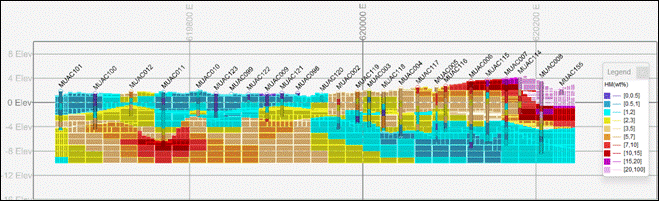
Figure 1. Proposed IMA MRE coloured by HM% and showing drill locations (V.E. = 1:7) Drill sections shown.

Figure 2. Drilling and model cross section 1 at 508750mN showing drilled and modelled HM%. (V.E. = 1:7)
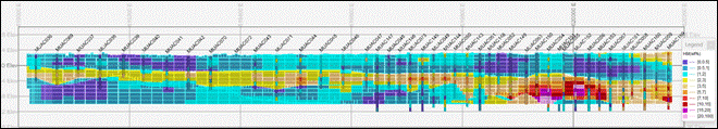
Figure 3. Drilling and model cross section 2 at 509150mN showing drilled and modelled HM%. (V.E. = 1:7)
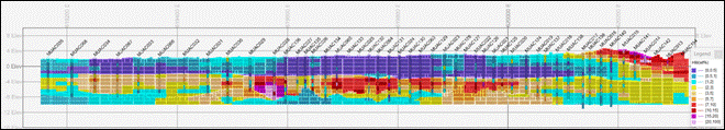
Figure 4. Drilling and model cross section 3 at 509550mN showing drilled and modelled HM%. (V.E. = 1:7)
Subsequent to an extensive QA/QC verification, validated drill hole and assay data tables were imported into Datamine Studio RM mining software and de-surveyed, using the Holes3D super-process, to produce a
Drill hole collar elevations were then projected vertically to the DTM topographic surface. The drill hole file was zoned according to the geological interpretation wireframes in the same order of addition as applied to the model construction.
The strike length of the Mineral Resource is currently 2.4 kilometres. The dimensions of the Mineral Resource are expressed in plan by the model boundary, which is limited by the extent of drilling or until the government land property boundary is reached. Currently it extends up to 1.3km in width and has an average depth of 7.9m. Mineralisation remains open to the north and south.
The bulk density applied to the MRE has been generated for each discrete geological domain. A component-based density algorithm, designed by
Datamine Studio RM was utilised in the computerised estimation of the resource. Interpolation of the resource drill hole data into the block model occurs using an orientated elliptical search volume defined by the trend of the geological unit or HM grade distribution. The interpolation is anisotropic and occurs discretely within each zone (hard boundary) according to the ZONE key field in both the model and drill hole file.
A discretisation array of 3 x 3 x 2 is employed for interpolation averaging into each cell. All cells/sub-cells are interpolated individually.
Model cells are populated by the search volume applied (EST=1, EST=2 & EST=3) to assist in defining mineral resource confidence levels. Those areas populated by the first search are allocated an Indicated status. A multiplication of the search volume by a factor of 3 and 5 was used for the second and third search, respectively.
The designation of resource category was simplified by the application of new drilling and analysis at a regular sample interval. The quality of informing drill, assay and mineralogy data, Lidar survey, the performance of QA/QC samples and the demonstrable geological and grade continuity also assisted in the classification of this resource.
The MRE was completed by the Company's Competent Person,
For further information, please visit www.capitalmetals.com or contact:
|
|
Via |
|
|
+44 (0)20 7390 0234 |
|
|
+44 (0) 20 7409 3494 |
|
|
+44 (0)20 7907 8500 |
About
Visit our website:
Follow us on social media:
LinkedIn: @Capital Metals plc
Competent Persons Statement
Information in this announcement relating to the drill assay results is based on data reviewed by
RNS may use your IP address to confirm compliance with the terms and conditions, to analyse how you engage with the information contained in this communication, and to share such analysis on an anonymised basis with others as part of our commercial services. For further information about how RNS and the