
("Power Metal" or the "Company")
Uranium
The update concerns work undertaken by Power Metal and Fermi Exploration ("Fermi"). Fermi is the uranium-focused joint venture (the "
HIGHLIGHTS:
·
· The planned 2,100m drill programme will test two major shear zones and the S-Zone underlying a significant uranium, cobalt and nickel soil anomaly.
· The target 'The 'S Zone' on the Property differs from most unconformity-related uranium targets in the
"The forthcoming drill programme at
While the deferment of drilling has been frustrating, the short delay has allowed the technical team to refine targeting and design a programme focused on testing the most compelling structural features identified to date.
DRILL PROGRAMME DETAILS
The initial three-hole drill fence is designed to test these structures at the unconformity and within the basement, with flexibility retained to adjust targeting as results are received.
Following the receipt of all required permits, Fermi will commence the updated 2,100m diamond drilling programme on
A full discussion on the S-Zone, the overlying geochemistry and the target's structural geology is presented in the Company announcement of
https://polaris.brighterir.com/public/power_metal_resources/news/rns/story/wk641yx
Permit Details
Permit Number 24-15-M0455 was issued to 102134984 Saskatchewan Ltd by the
Target Details
The target at
Structurally focused uranium mineralisation is well documented elsewhere in the
The Eastern and Western Shear Zones are ~200 m wide and display reduced velocities (2,800-2,900 m/s), implying ~40% lower competence than the surrounding geology. These properties are consistent with fractured and/or altered structural corridors that may represent preferential permeability pathways. The conductive anatomy, location shown in Figures 1 and 3, is currently anticipated to represent alteration, a key component of Athabascan Unconformity related systems.
The inverted gravity data shows a gravity high between these two shear zones; the composition and causation of this gravity high are unknown, but the density matches that of silicified quartz, which is a common alteration feature within the sandstones and underlying basement of the
In unconformity-related uranium systems, strong mechanical contrasts between competent, silicified geology and adjacent weaker fault or shear zones are recognised to localise deformation, promote dilation during reactivation, and focus hydrothermal fluid flow. Such structurally focused permeability contrasts are a common control on uranium deposition in the
Taken together, the coincidence of major shear zones, gravity anomalies consistent with silicification, reduced rock competence and anomalous uranium, and other elements associated with Athabascan uranium deposits in soils provides a coherent structural-hydrothermal target, potentially capable of focusing mineralising fluids at and below the
Drilling Targets
The unconformity is expected at depths of around 220 to 260m, due to the possibility of polymetallic (U ± Ni, Co, As), which is basement-hosted elsewhere in the
To test key target geology, an initial three-hole drill fence is planned, as shown in Figure 1, and in profile in Figures 2 and 3.
· Drillhole BL2026_01 is proposed as an inclined hole (-60°) drilled on an azimuth of 340°, to a planned depth of 550m. This hole is designed to test for uranium mineralisation associated with the basement expression of the
· Drillhole BL2026_02 is proposed as a vertical hole to a planned depth of 450m, located approximately 280m northeast of the collar of BL2026_01. This hole will test for uranium mineralisation at the interpreted apex of the
· Drillhole BL2026_03 is planned approximately 250m southwest of the collar of BL2026_01. This 500m long vertical hole is designed to test for uranium mineralisation at the apex of the Western Shear Zones, and along the shear zone itself, including its intersection with the unconformity.
Sufficient meterage budget exists for further drillholes; however, with the enigmatic geology of
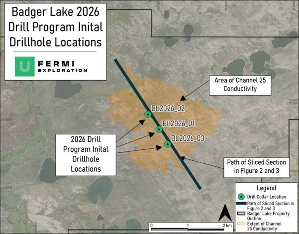
Figure 1: Location of the Drillhole Locations, the Channel 25 Conductive Feature, and the sections presented in Figure 2 and 3.
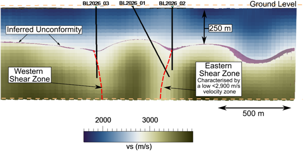
Figure 2: Side view of the ANT profile (scale provided), including the inferred unconformity, inferred basement faulting and the proposed drillhole locations. View is looking 54° to north east.
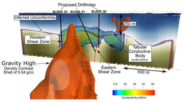
Figure 3: 3D oblique geological section of the ANT profile, including the inferred Unconformity, inferred basement faulting, the gravity high (Density Contrast Shell of 0.04 g/cc), and the conductive body at the unconformity. The proposed drillhole locations are also shown. Planar section of the ANT profile is cut at 144°.
GLOSSARY
|
Alteration |
Changes to the mineralogy, chemistry, or physical properties of rocks caused by hydrothermal fluids, commonly associated with mineralising processes. |
||
|
Basement |
Crystalline rocks underlying the |
||
|
Competence (Rock Competence) |
A measure of the mechanical strength of rock; lower competence generally indicates more fractured or altered material that may enhance fluid flow. |
||
|
Conductive Anatomy |
Subsurface features identified by geophysical methods that exhibit enhanced electrical conductivity, often associated with alteration zones, faults, or graphite. |
||
|
Diamond Drilling |
A drilling technique that uses a diamond-impregnated drill bit to recover continuous cylindrical rock samples (core) for geological analysis. |
||
|
|
||
|
Silicification |
An alteration process involving the introduction of silica into rock, increasing density and competence; commonly observed in |
REFERENCES
1 Li Zenghua,
QUALIFIED PERSON STATEMENT
The technical information contained in this disclosure has been read and approved by Mr
This announcement contains inside information for the purposes of Article 7 of the Market Abuse Regulation (EU) 596/2014 as it forms part of
For further information please visit https://www.powermetalresources.com/ or contact:
|
|
|
|
|
+44 (0) 20 3778 1396 |
|
|
|
|
SP Angel Corporate Finance LLP (Nomad and Joint Broker) |
|
|
|
+44 (0) 20 3470 0470 |
|
|
|
|
|
|
|
|
+44 (0) 20 3882 2868 |
|
|
|
|
BlytheRay ( Megan Ray /Rachael Brooks/Alastair Roberts |
+44 (0) 20 7138 3204 |
|
|
NOTES TO EDITORS
Power Metal Resources plc - Background
The Company has a principal focus on opportunities offering district scale potential across a global portfolio including precious, base and strategic metal exploration in North America, Africa, Saudi Arabia, Oman and Australia.
Project interests range from early-stage greenfield exploration to later-stage prospects currently subject to drill programmes.
Power Metal will develop projects internally or through strategic joint ventures until a project becomes ready for disposal through outright sale or separate listing on a recognised stock exchange thereby crystallising the value generated from our internal exploration and development work.
Value generated through disposals will be deployed internally to drive the Company's growth or may be returned to shareholders through share buy backs, dividends or in-specie distributions of assets.
RNS may use your IP address to confirm compliance with the terms and conditions, to analyse how you engage with the information contained in this communication, and to share such analysis on an anonymised basis with others as part of our commercial services. For further information about how RNS and the